
Maku City

Why Maku

Geog. Position

Population

History & Culture

Strategic Plan

Business Subjects

Maku at A Glance
Why
Maku ?
Maku ?
Why
Geographical Position
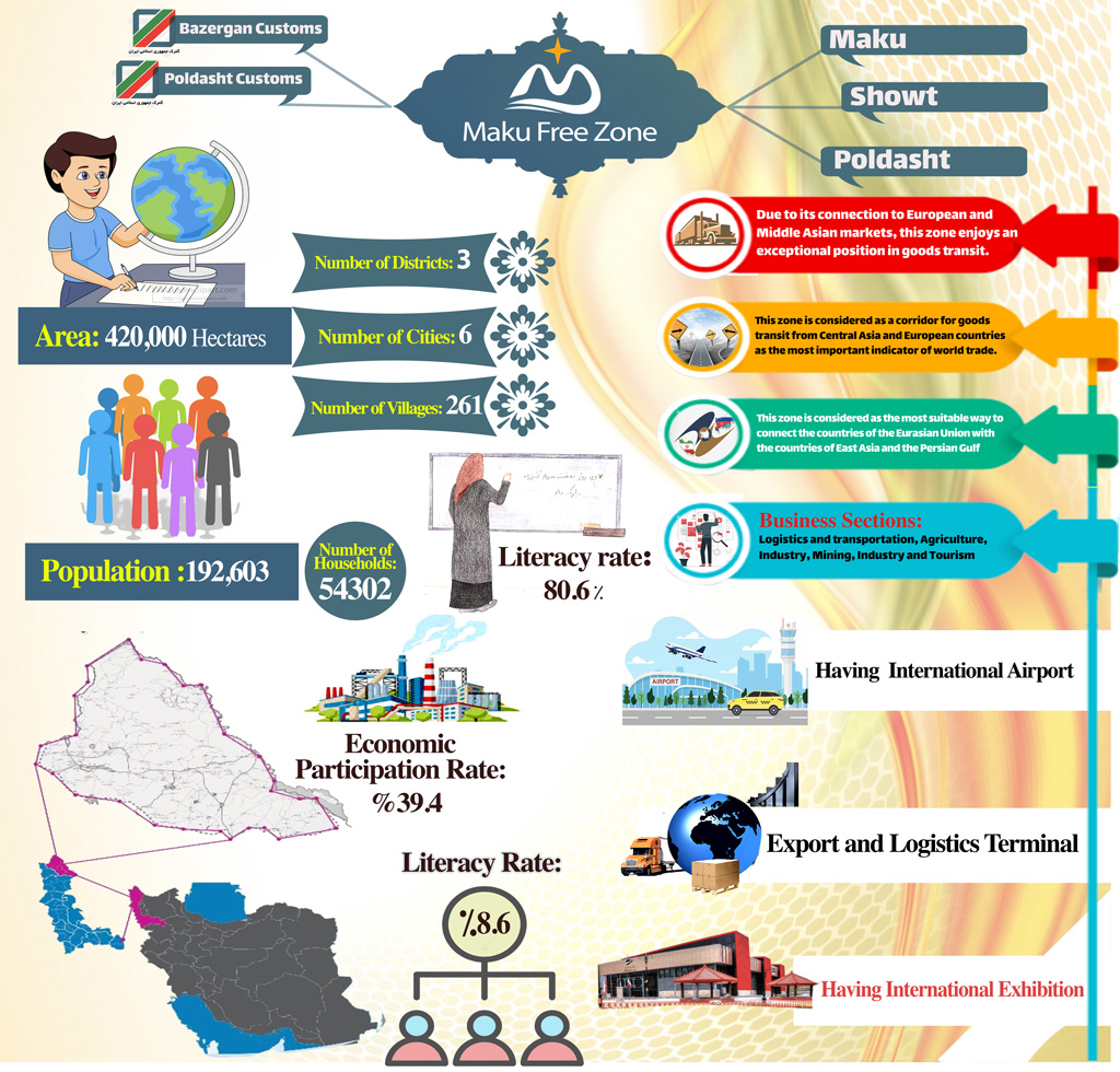
Geographically, Maku Free Zone encompasses Maku, Showt, Poldasht and Bazargan border city, which is located in the northwestern tip of the country and occupies about 75% of the country’s free zones. This zone is located next to Turkey and the Republic of Azerbaijan (Nakhchivan Autonomous). Border length of the Islamic Republic of Iran in this zone is 140 km and 130 km with the Republic of Azerbaijan and Turkey, respectively. In terms of country divisions, Maku Free Zone with an area of ۳۸۶۰ square kilometers encompasses 3 counties, 6 cities, 6 districts, 13 rural district and 261 inhabited villages. According to the general population and housing census of 2016, the population of the region was 192,603 people, which is 0.24% of the total population of the country and 5.9% of the total population of West Azerbaijan province.

Maku Free Trade-Industrial Zone, in addition to bordering Turkey and Nakhchivan, is adjacent to Armenia and the Caucasus region, and is the bottleneck of the North-South land corridor (on land rival of the Suez Canal) and the junction point of Asia and Europe. Considering the importance of the Caucasus’s strategic transportation for Iran, major trade and political exchanges between Iran and Europe are in through this path. The short distance of Maku Free Zone from the ports of Mersin in the Mediterranean Sea and Trabzon in the Black Sea is a significant advantage in accessing European markets through land and sea, compared to the southern ports in the Persian Gulf. Regarding distance and economical expenses, there is no doubt that this region is the most economical bottleneck on land in comparison to the east-west sea route.
Urban and Rural Population
Ratio to the population of the whole country
۰.۲۴ %
Ratio to the total population of the province
۵.۹ %
Literacy rate
۸۰.۶ %
Ruralization rate
۴۹ %
Economic participation rate
۳۹.۴ %
Unemployment
۸.۶ %
According to the general population and housing census of 2016, the population of the zone was 192,603 people, which is 0.24% of the total population of the country and 5.9% of the total population of West Azerbaijan province. This zone has 54,302 families and the sex ratio is 105. Out of this number, 71586 people are urban (27.35%) and 131353 people are rural (73.64%). In addition, according to the general population and housing census of 2016, the literacy rate is 80.6%, the ruralization ratio is 49%, the economic participation rate is 39.4% and the unemployment rate is 8.6%.
History and Culture
The oldest historical buildings in Maku date back to the Urartu or Khalid period. Stone rooms in the villages of Sangar (Maku-Bazargan) Chirkandi in Chay Basar and Delik Dash in Siyah Cheshmeh and Sheddi in Aras near Poldasht, and the discovery of cuneiform inscriptions in Bastam village and around Bazargan and the excavations and discoveries of the German delegation in Qara Bastam and the deciphering cuneiform inscriptions by Iranian and foreign archaeologists and the writings of ancient and modern historians such as Musa Khoren (Armenian) and B.B. Pyotrovsky (Russian) prove that the original inhabitants of Maku were the Urartians. Rosa, their biggest city, was built near the village of Bastam.
Castles
Historical Castle of Qaban
This castle known as Qaban Castle dates back to about 600 years ago that is to the Timurid era.
Mountains
Stone Arch of Qayeh
The stone arch of Qayeh with a -40 slope is located in the ancient part of Maku and with 200 meters height, 25 meters radius and 250 meters length is the third curved stone arch in the world after the stone arches of Brazil and France.
Strategic Plan
Strategic Plan
Business Subjects
Logistics and Transportation
Being the most important commercial and passenger border of the country on land, Bazargan and Poldasht borders are located in Maku Free Zone, in addition passage of the east-west corridor through this zone which connects China to Europe through railways and road transit routes, has turned logistics and transportation industry into the most important business subject in Maku Free Zone. The region has the potential to create added value in regional and international trade flows with an annual trade volume of over $ 1,000 billion.
Being on China-Europe trade route, reduction of cost and time in transiting goods, passage of export gas pipeline and access to cheap energy sources, talented labor force as well as tax and customs exemptions, Maku free zone holds a unique position on regional and international trade and on the global supply and production chain, especially by using the potentials of the 25-year strategic agreement between Iran and China, which makes this region attractive for investment and transit of goods.
Holding the capacity to implement combined transport along with the ongoing Tabriz-Kars railway, besides Maku International Airport, Sardar Soleimani Highway, and the ongoing project of the logistics village of Maku Free Zone, along with a significant number of fleet owners and transport companies have turned Maku Free Zone into a place to become a logistics hub for production and exports.
Agriculture (Agronomy, Horticulture, Animal Husbandry and Fisheries)
Presence of 10 dams which are holding 420 million cubic meters of water, flooded rivers along the great Aras River and having about 98,000 hectares of arable land and 32,000 hectares of pressurized irrigation network in Maku Free Zone are among the potentials of this region for the development of agricultural activities. Annual production of 260,000 tons of horticultural, agricultural, livestock, fishery and natural honey products in Maku Free Zone, as well as the preparation of downstream lands of the dams in Maku Free Zone for investment by agro-industrial companies, construction of greenhouses and large industrial farms and affiliated industries creates a huge capacity to set up processing, conversion and packaging industries that complete the production cycle and create employment in the region. In addition, production and export of lobster and aquatic animals using the capacity of Aras River, has placed this region on top of non-coastal cities of the country regarding aquatic production.
Mining and Mining Industries
The only free zone in the country, Maku Free Zone, has various mines with high reserves and 25 active mining units, and due to the exploration operations in the form of two areas in the whole region by IMIDRO organization, there is a huge capacity to invest in the field of discovered mines. Preventing sale of raw materials, processing minerals and completing its chain, due to abundance of decorative and facade stones, magnesite, silica, copper, iron, basalt and construction materials, are among the goals of Maku Free Zone Organization.
Industry
Presence of five on-stream industrial towns with an area of ۳۰۰ hectares in the region and two under construction industrial towns with an area of ۲۰۰ hectares with more than 125 on-stream industrial units along with foreign investors from China, Turkey, Canada and India, as well as production of unique products including dentures, edging tape, honeycomb paper, flooring and wall coverings, etc., and accessing skilled labor force, has turned the field of industry into another central business in this region. Maku Free Zone Organization by accomplishing all administrative processes including issuing various types of licenses and delivering land with minimal bureaucracy and focusing on the formation of export-oriented production units to meet domestic needs and reduce imports, completing the industry chain based on relative advantages focusing on handicrafts, animal husbandry, clothing, leather, furniture and cosmetics, sanitation and ferroalloys have formed a bright future for the industry of this region.
Tourism (Nature and Ecotourism)
Maku Free Zone, as one of the most remarkable tourist destinations in the country, hosts more than two million and five hundred thousand domestic and foreign travelers annually. Having pristine nature, diverse climate, numerous tourist attractions and historical monuments, have turned this zone into a destination for investment on construction of accommodation centers, eco-tourism resorts, recreation and leisure centers (such as zip line, karting, ski slope, cable car, etc.), shopping centers (such as the Grand Border Bazaar and Omid Bazaar) and Multi-purpose complexes such as Azarmal, etc. It holds an unparalleled capacity in setting up a variety of sport centers, water and beach recreation spaces, health tourism centers and the handicrafts development, especially carpet and rug weaving.
Maku at A Glance
Maku at A Glance
All Rights Reserved to Maku Free Zone Organization.